Showing 19271 — 19280 of 29552 Items
November 10, 2016
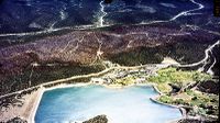
Mescalero Apache Mountain Inn
November 10, 2016
Find out how maps get made and who makes them at this year’s Geographic Information Systems (GIS) Day on Wednesday, Nov. 16 from 9 a.m. to 2 p.m. The event is held in conjunction with the Geography Awareness Week, Nov. 13–19, and is hosted by the Earth...
By Shar Spalding
November 10, 2016
A recent survey of students at The University of New Mexico shows a majority of students believe UNM is doing a good job of educating, preventing and responding to sexual misconduct and assault. However, some students are still at a higher risk of being...
November 10, 2016
A recent remote sensing demonstration was attended by representatives from UNM, San Diego State University, BAE Systems Inc., Civil Air Patrol and NMDOT.
November 10, 2016
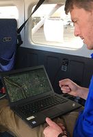
Geography & Environmental Studies graduate student Jesse Sprague preparing the remote sensing system for a flight test.
November 10, 2016
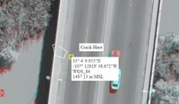
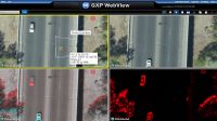
Interpreted products are centralized into a common portal for access by emergency and transportation managers.
November 10, 2016
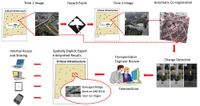
This diagram explains how the remote sensing process works.
November 10, 2016
This Civil Air Patrol aircraft at Kirtland Air Force Base has been outfitted with the remote sensing hardware system.
November 10, 2016
Engineers access the data products through a web browser where they can provide their expert interpretation of the status of the infrastructure.
By Aaron Hilf
November 10, 2016
In the wake of natural disasters, being able to quickly and accurately assess the damage to roads, bridges and other critical infrastructure can save lives. That fact is one of the driving forces for a University of New Mexico research team making big strides in the field of remote sensing.
Showing 19271 — 19280 of 29552 Items